
September 15, 2025
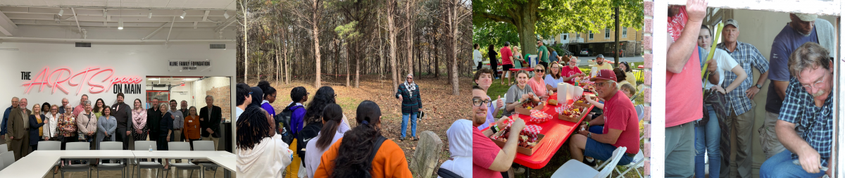
Preserve Arkansas announced its 2025 Most Endangered Places list on September 12 during its Annual Membership Meeting at El Dorado, which was held in conjunction with the Destination Downtown conference. The 2025 list comprises six properties, including an early Argenta building, a downtown Fayetteville neighborhood, a remote African American church at Pickens, a Hot Springs home believed to be the oldest of its kind, a Little Rock building important for its aviation history, and a historic Fayetteville cemetery.
“We look forward to working with property owners and local advocates to chart a path forward and find solutions to save these irreplaceable community assets,” said Rachel Patton, executive director of Preserve Arkansas.
The Most Endangered Places Program began in 1999 to raise awareness of historically and architecturally significant properties facing threats such as demolition, deterioration, and insensitive development. Preserve Arkansas solicited nominations from individuals and organizations throughout the state, and a selection committee of preservation professionals, architects, historians, and Preserve Arkansas members chose properties based on their level of significance, severity of the threat, and level of local support. The list is updated each year to generate discussions and support for saving the places that matter to Arkansans.
Six to Save: The 2025 List of Arkansas’s Most Endangered Places
Duncan/Hill Neighborhood, Fayetteville (Washington County). Comprising three early additions to the City of Fayetteville, the historic Duncan/Hill Neighborhood has been an important source of attainable housing near downtown Fayetteville and the University of Arkansas. Sadly, many historic buildings have already been demolished to make way for student housing complexes, threatening to erase the human scale buildings and character of the neighborhood.
East Mountain Cemetery, Fayetteville (Washington County). The East Mountain Cemetery surrounds the Walker Family Plot on the western slope of East Mountain, also known as Mount Sequoyah, overlooking downtown Fayetteville. Some of the region’s earliest white settlers are buried there, along with Fayetteville’s early Black residents, many of whom were enslaved by, or worked for, the Walker family after the Civil War. The cemetery is in need of comprehensive mapping and marker and fencing restoration.
Faucette Building, North Little Rock (Pulaski County). The 1890 Faucette Building was constructed by brothers William C. and James P. Faucette, both of whom were pivotal figures in North Little Rock’s early history. It originally served as a restaurant/saloon and rooming house because of its proximity to the railroad. Located at the prominent corner of 4th and Main in the Argenta Historic District, the building’s southern wall features the popular “Dogtown Proud” mural by artist Kevin Kresse. The building, now vacant and deteriorated, is for sale.
Former 154th Observation Squadron Headquarters, Arkansas Air National Guard, Little Rock (Pulaski County). The hangar on Bond Avenue in Little Rock was built in 1937 by the WPA and later served as the headquarters of the 154th Observation Squadron of the Arkansas Air National Guard. Until recently, the building was home to Central Flying Service’s prop shop. The master plan for Clinton National Airport indicates the eventual removal of the structures along Bond Avenue for aircraft ramp expansion. With stabilization and environmental upgrades, the building could remain in use for aviation training support and community service.
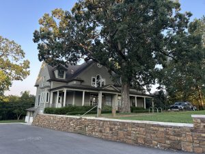
Dr. William P. Passmore House, Hot Springs (Garland County). The 1873 home of Hot Springs druggist Dr. William Pauldin Passmore remains one of the oldest Second Empire residences in Arkansas. Added to the National Register in 1976, the once exemplary home has been vacant and deteriorating since the death of Passmore’s granddaughter in 1977. Now under new ownership, there is hope that the home could be rehabilitated for a use that allows the public to access and enjoy the property.
Syrene Missionary Baptist Church and Cemetery, Pickens (Desha County). The 1937 Syrene Missionary Baptist Church traces its roots to 1888, when property along Bayou Bartholomew was gifted to the African American congregation by local landowner R. J. Hyatt. The structural integrity of the church is threatened by age-related decline, and frequent flooding of the only access road renders the church unreliably accessible. A successful save would remedy this with road grading and improvements, assessment of the church, and survey and repair of grave markers in the associated cemetery.
Photos and additional information about 2025’s Most Endangered Places are available below.
The Duncan/Hill Neighborhood consists of three early additions to the City of Fayetteville: Duncan’s, Putman’s, and Stone’s Additions. All three families were prominent in early 20th century Fayetteville. Because of the neighborhood’s location immediately south of the University of Arkansas campus, many of these families’ original homes have long since been demolished to make way for apartments and most recently, extremely large student housing complexes. Of the remaining original structures, two are eligible for individual listing in the National Register of Historic Places, and the neighborhood overall may retain enough historic fabric for a small National Register historic district, providing access to preservation incentives like Federal and State Historic Tax Credits. The City of Fayetteville recently contracted with Post Oak Preservation Solutions to conduct a windshield survey of historic properties, and this neighborhood will be included in that survey. A successful save would see the neighborhood’s remaining historic buildings retained and rehabilitated to provide attainable housing for people at different income levels and stages of life in downtown Fayetteville.

Located on land once owned by Fayetteville’s prominent Walker family, the East Mountain Cemetery surrounds the Walker Family Plot and is located adjacent to the Fayetteville Confederate Cemetery. The cemetery occupies nearly 1.2 acres on the western slope of East Mountain, also known as Mount Sequoyah, overlooking downtown Fayetteville. The oldest headstone in the cemetery dates to 1852; however, there is evidence of a burial there dating to 1838. Some of the region’s earliest white settlers’ names appear on headstones, and in far corners of the cemetery, sunken sandstone markers, unmarked depressions, and chiseled sandstone mark the burials of Fayetteville’s early Black residents, many of whom were enslaved by, or worked for, the Walker family after the Civil War. Most of these individuals lived near the cemetery in southeast Fayetteville’s Black community. Fayetteville’s East Mountain Cemetery is significant for its association with the early social history and broad patterns of settlement in northwest Arkansas, and as such it is eligible for the National Register of Historic Places. A successful save of the cemetery would include arranging for Ground Penetrating Radar to identify unmarked graves, restoration of damaged markers, installation of new fencing, and mitigation of drainage issues on the hillside site.

The Faucette Building in North Little Rock’s Argenta Historic District is significant not only for its age and location but for its provenance. Because of the location’s proximity to the railroad line that used to run east and north of the site, the Faucette brothers built the structure in 1890 to house a restaurant/saloon and rooming house. The building featured Argenta’s first electric lights, and its original façade faced the east, toward a nearby passenger train depot, which is why the east façade is more ornate than the repositioned façade, currently on Main Street. Brothers William and James Faucette were instrumental in establishing North Little Rock as a city independent of Little Rock, which had annexed the area in the late 19th century. The brothers were, respectively, Argenta’s first and third mayors. Located at the prominent corner of 4th and Main in Argenta, the building’s southern wall features the popular “Dogtown Proud” mural by artist Kevin Kresse. This building, which in recent memory housed vision and dental clinics, is now vacant and deteriorated. The Faucette Building is currently for sale. A successful save would see the building purchased and rehabilitated using Historic Tax Credit incentives and once again put back into use.

The hangar on Bond Avenue in Little Rock was built in 1937 by the WPA and later served as the headquarters of the 154th Observation Squadron of the Arkansas Air National Guard. The Arkansas Air National Guard occupied the hangar from February 1952 to October 1962, when it and the 189th Tactical Reconnaissance Group relocated to the Little Rock Air Force Base. In 1927, 10 officers and 50 enlisted members of the 154th Observation Squadron performed relief duties during the Great Mississippi River Flood, one of the worst natural disasters in American history. The squadron was ordered to active duty in 1940 and saw action during WWII in North Africa, Italy, France, and England, and then again in 1950 during the Korean conflict. Until recently, the hangar was home to Central Flying Service’s prop shop. The master plan for Clinton National Airport indicates the eventual removal of the structures along Bond Avenue for aircraft ramp expansion. With stabilization and environmental upgrades, the building could remain in use for aviation training support and community service. A successful save would secure not just the preservation of the structure but increase the activities and income potential of the airfield while training future aviators.

Dr. William Pauldin Passmore, a former Union Army surgeon, became one of Hot Springs’s most successful druggists after the Civil War, operating multiple drugstores during an economic boom between 1870 and 1890. In 1873, he built the Passmore House on Park Avenue, then the city’s most prestigious residential area. The house remains one of the oldest and most iconic Second Empire residences in Arkansas. Its interior featured a paneled dining room with a painted dome ceiling that originally incorporated a stained-glass skylight and unusual built-in ice boxes in second-floor bedrooms, gifted to the family by the wife of another leading physician. The home was added to the National Register of Historic Places in 1976 under the ownership of Passmore’s granddaughter, Wilhelmina Lea, a prominent community member and county historical society founder. After her death in 1977, the property fell into neglect, remaining vacant and deteriorating due to poor maintenance, weather exposure, and trespassing, leaving it in a state of significant disrepair. The home is now under new ownership, and a successful save would see the residence fully rehabilitated with the help of Historic Tax Credit incentives.

The Syrene Missionary Baptist Church traces its roots to 1888, when property along Bayou Bartholomew was gifted to the African American congregation by local landowner R. J. Hyatt. However, evidence suggests that the congregation met there before the 1880s. According to oral tradition, an earlier church structure was destroyed by fire, and the current church was built in 1937. Baptisms were performed in Bayou Bartholomew, a common practice for contemporary congregations up and down the bayou. The church cemetery’s earliest surviving marker is hand-carved in concrete with a death date of 1907, and there are at least two stone markers supplied by the Mosaic Templars of America in the 1920s. While there are 36 grave markers visible today, unmarked graves are undoubtedly present. The primary threat is a lack of physical accessibility to the site. The church can only be reached by farm roads, including a half-mile stretch that is frequently flooded. Furthermore, the integrity of the structure itself is threatened by weather and age-related decline. A successful save would include road grading and improvements, a condition assessment of the church, a Ground Penetrating Radar survey of the cemetery, and the clearing and development of interpretive signage along the bank of Bayou Bartholomew commemorating the significance of this cultural landscape.
Thank you to our selection committee members!
Lori Filbeck-Hart, AIA, Chair, Springdale
Heather Davis, AIA, Little Rock
Danielle Housenick, Russellville
Rachel Whitaker, Springdale
Ashley Sides, Little Rock
2024 List of Arkansas's Most Endangered Places
2023 List of Arkansas's Most Endangered Places
2022 List of Arkansas's Most Endangered Places
2021 List of Arkansas's Most Endangered Places
2020 List of Arkansas's Most Endangered Places
2019 List of Arkansas's Most Endangered Places
2018 List of Arkansas's Most Endangered Places
2017 List of Arkansas's Most Endangered Places
2016 List of Arkansas's Most Endangered Places
2015 List of Arkansas's Most Endangered Places
2014 List of Arkansas's Most Endangered Places
2013 List of Arkansas's Most Endangered Places
2012 List of Arkansas's Most Endangered Places
2011 List of Arkansas's Most Endangered Places
2010 List of Arkansas's Most Endangered Places
2009 List of Arkansas's Most Endangered Places
2007 List of Arkansas's Most Endangered Places
2006 List of Arkansas's Most Endangered Places
2005 List of Arkansas's Most Endangered Places
2004 List of Arkansas's Most Endangered Places
2001 List of Arkansas's Most Endangered Places
2000 List of Arkansas's Most Endangered Places
1999 List of Arkansas's Most Endangered Places